Fun Days in Bernal Heights

Today I’m feeling deep appreciation for our sweet neighborhood in Bernal Heights. I spent the morning writing a book review in Pinhole Coffee, chatting with people sometimes and feeling thankful for JoEllen’s lovely cafe which gives such a good space for local community.

On the way home I ran into Frank from Good Life (we always say hello) and then Mike from Progressive Grounds who was blasting his friend’s band playing a cover of Minor Threat song from his bicycle.

Between the time I left and the time I came back, someone took half the books from our Little Free Bookshelf – leaving one of the guidebooks to Paris and the Penguin copy of Moby Dick. (Glorified name for what is just a wooden wine box on end, under the porch awning. It’s fun when other people leave books there, and I often read them and put them out again.)

I picked up some trash from the sidewalk and put it into the bin under our sidewalk bench made of stumps and a board. Someone sat there last night and had take out food and a cigarette. Someone else often comes and drinks a glass bottle of Squirt there, leaving the bottle… I wonder who it is, and I like them for having a habit, secretly visible to me though I never see them, only their distinctive bottles.

Running into Marc from Unicorn Precinct and having a rambly, jumping, lightning speed conversation about books and poems. He was reading Daniel Borzutzky and I felt like I recognized him (from ALTA conferences?) I told Marc about the neobaroque movement and he talked about his children’s play “Factory Full of Weasels”. Danny critiqued his copy of Jacobin magazine a bit (it has nice layout tho) and we both excitedly tried to explain the weird awfulness of “Politics and Apocalypse”. (Shudder.)

Down the street doing a quick errand I was chatting with El Ahorro owner and family as they are opening a sandwich shop in the back of the store – already a great neighborhood store.

Friends who live close by, coming over this afternoon for end of the year tea and black eyed peas.

The guy a few houses down must still be on vacation, his perpetual barbershop-and-garage-sale still closed for the holidays.

Next week I’ll go to the two free tai chi classes, one at the library, one at the senior center, a new habit in the making which will bring new acquaintances I’ve likely seen around the neighborhood.

It’s nice to live somewhere for years, to see the same people every day, in my usual haunts, feeling just a little connection to others, the opposite of isolated, knowing the usual ways the fog and afternoon wind rolls in and out through the gap in the hills, kind of like how we were aware of the tide when we lived on the houseboat in Pete’s Harbor.

[photo: a tiny zine called Fun Days in Bernal Heights, by the downtown zine kiosk owner]
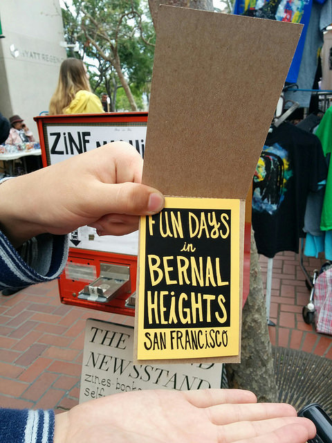
Bernal zine

A wild augmented reality appears!

As I went up the hill to get groceries today, from across the street I hollered “Well hey there! I see you’re catching a Pokémon!” to a guy in front of the Bernal Heights library. He barely even turned to look at me as I rolled up but he giggled and replied “Yep, lots of Zubats in this neighborhood!” Just a normal conversation between strangers apparently taking a photo of a blank wall of a public building!

I am level 4, I have an egg in the incubator and am all hot to get to the point where I can fight a Pokémon in my local Pokégym. Sorry but you will all have to get used to people talking like this. Welcome to the future.

As I have played Ingress for the past 3 years a bit obsessively I am very happy Niantic has this massive success. And also proud that some of my portals and photos and descriptions are integrated into Pokémon Go. I still prefer the elegance and game balance of Ingress, and the interesting social behaviors and structures that have evolved for it. (I can go to any city, and find Ingress portals and talk to its players; instant social group.) But I can see cool potential and the greater mass appeal of the new game built on the bones of Ingress data & infrastructure.

I know people will hate on this game for many reasons. It’s popular (yet dorky) for one. It will make people mad that others are doing something pointless. Its selfies will infuriate the grumpy people who hate the idea of self-portraits. People will inevitably walk into buses and off of cliffs and cause poké-stop-while-driving accidents. But I love this moment, the huge surge of cultural awareness as the game spreads. By tomorrow, people will start writing mainstream articles explaining the entire phenomenon or discussing why you should or shouldn’t let your kids play the game.

For me it is a beautiful and historic moment as it feels like a level up for mass participation in a virtual or augmented reality. This has plenty of potential for good and bad. It will spark people’s imaginations, even as it drives us further into ubiquitous surveillance of our location data and habits. Part of the cool thing is it creates a shared imaginary world and a geographic overlay to our real world. Combined with the powerful impulse we have to collect things and know trivia it will be a collective and somewhat guilty pleasure of people who have the money and privilege enough to have a lot of data bandwidth on their mobile devices. And who don’t mind handing even more of their data over to “the cloud”.

We can build strong memories and shared experiences that stay with us for years in game play. That will be enhanced by using the geography of the world around us!

Unlike the bohemian and esoteric pleasures of ARG-ing this is a swift popular movement of millions of people joining the game. It’s huge! I expect it to very rapidly become a placeholder or touchstone for people’s fears and dreams about technology. We will see a sort of mythos develop around it like the way you can see nuances and divisions in how people approach the idea of Minecraft. Something that they use as a container for the idea that young people these days, or whoever, aren’t properly politically engaged or doing the correct things or are sheep following pop culture; and/or an activity that is frightening, incomprehensible, t hat makes us vulnerable; and/or a social technology that could unlock something like the collaborative power of flash mobs.

The first attempt to make a game like this I am aware of was called “Pod” (annoyingly hard to Google) in the early/mid 90s. It was a small handheld device, like a tamagotchi gadget, on which you could collect parts to build little insectoid robots. In theory you would come across other Pod players in the real world at random and could trade parts in order to evolve your robo-insect things. I don’t remember how they communicated with each other. I only came across a random stranger to trade Pod pieces with once, in a mall in San Jose, after many months of carrying it around. The Pod was supposed to somehow be educational about the idea of Darwinian evolution! At the time this game was very exciting, but it didn’t pan out.

Anyway, we aren’t yet all walking around wearing dystopian headsets but I expect more AR overlays to come, maybe historical details so you can step through time on the map where you’re walking, maybe layers that are more artistically complex (though ludic complexity is also art!) or overtly political.

Driving around, I waste more time

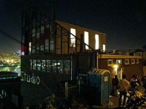
This afternoon we drove around searching for the building I’ve seen and wondered about for years. It’s visible from Highway 101, is topped with giant panels of stained glass, and says “STUDIO” on the side in white letters. “Studio” is not very google-able. It’s in a neighborhood in San Francisco called Silver Terrace, just west of Bayview and east of Portola. STUDIO, after we tracked it down and did some sleuthing, turns out to be Church Art Glass Studio owned (or formerly owned?) by Nick Lukas. Above the front door there’s an awning made of the same colors of glass as are on top of the building, throwing intense colored shadows. Framed stained glass panels were in the dusty windows. The hill was very green & lush. I love corners of neighborhoods that are mostly full of industrial buildings and warehouses for floor tile and stuff like that. This area has the added bonus of being mostly underneath a highway.

church art glass studio

The majority of windows at St. Michael [in Livermore, CA] were done by the Church Art Glass Studio of San Francisco, which has designed windows for the churches on the West Coast and Hawaii since the turn of the century. The original owner, Edward Lopolka, advertised as “artists in stained glass, German and English antique.” The business was sold in the 1940’s to the father of Nick Lukas, who continues to operate the business in the shadow of the 280 freeway.

I felt like I solved a mystery only to come up with several more mysteries.

Mystery #1: Is the Studio still open? It looked deserted. A post from 2009 says Lukas was trying to sell his entire stock of art glass. It looks like we only just barely missed a very cool art show hosted there, Virtuoso.

Mystery #2: What is the hill of Silver Terrace called? It doesn’t seem quite like it would be named “Silver Terrace” but that’s what I’m going to have to call it. (ETA: I think it’s Mount St. Joseph! Source: How Many Hills are in San Francisco?

Mystery #3: What is that funky deserted building at 432 Paul Avenue that looks like an old school next to an equally funky factory? It’s beautiful!

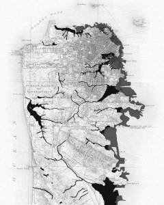
Silver Terrace was in the Rincón de las Salinas and Potrero Viejo Mexican land grants, sold off by the Bernal family in the 1860s. Actually it sounds like General Sherman foreclosed on the Bernal mortgage and then sold it off to J.S. Silver who subdivided it into lots, so it’s a very old San Francisco neighborhood. You can see from old maps that Bernal Hill is on one side of the bay inlet where Islais Creek was, that was eventually filled in to become Bayview, and the mystery hill that isn’t called Silver Terrace is on the other side, just east of Hunters Point Ridge.

San Francisco coastline and crreks

Here is a fantastic history of the area!

History of Bayview and Hunters Point (pdf)

We ended up going through McLaren Park which we had looked up beforehand – making fun of videos of hippies dancing to very boring music at Jerry Garcia auditorium – And pausing to look out over the valley below & trying to figure out what everything was. It was mostly Visitacion Valley, Bayshore, and the Cow Palace. I’ve never been there. We drove through and the most I can say for it is that I plan on going back to the huge Savers thrift store on Geneva. If there was a there there in Visitacion Valley I didn’t find it. I did wonder about what the Visitation was – something like the Annunciation which I do know is when Mary finds out she’s preggers – It turns out it’s when Mary’s pregnant and knows it, and goes off for a visit with another pregnant lady. I could rewrite that in my head to be all about pregnant ladies being supportive of each other instead of all the stuff about creepy babies leaping in the womb because of getting weird telepathic messages from other babies!

Back on Mission in the Excelsior neighborhood we were tempted by the Chicken Coop restaurant which looked amazingly retro. I couldn’t park though so we decided to go home and make omelettes. Signs informed me that Excelsior Welcomes the World. I will definitely return to work my way through all the small grocery stores on Mission. They look great. Anyway, we changed our minds about dinner again a few blocks later when we passed Joe’s Cable Car. Joe’s Cable Car turned out to be not the greasy cheap diner I thought it was. It is more the Dr. Bronner’s of Burgers. Everything at our table was covered in rambling, old-school sales talk and folksy wisdom about the magic of GROUND STEAK from, presumably, Joe. By the time we ordered our food I couldn’t bring myself to say the word “burger” because of the incredible amount of text about GROUND STEAK I had just read and all about the sharp knives, the way they butcher it all and grind it right there practically at your table, and how Joe himself and his jolly butchers were ready to Down-Home-ily bring a cow right to your house straight from the Gold Rush, and grind it up, unlike the evil fast food industry and its evil, evil breadcrumbs and midwest factory slaughterhouses, so please fork over 14 bucks for your Ground Steak while you enjoy the wolf-whistle of the doorbell and the singing santa christmas lights and the giant neon signs shaped like the Golden Gate Bridge, while sitting in something that in 1965 used to either be, or look like, a cable car. I had a great time and the burger was delicious.

The myth of the place and what I was about to eat had completely sold me on the restaurant before I had even sipped my coke. It was overwhelming especially to sensitive, neurotic artists who had gone to look for America and been driving around all day. It reminded me a little of the 1000 mile trip I took around the Southwest where through three states I saw billboards advertising “The Thing!” and then finally got to “The Thing!” roadside attraction and was so freaked out by its Americana-ness that I wrote several chapters of an autobiographical novel about it.

As usual, Oblomovka navigated and looked things up on his G2 while I drove and made a lot of spontaneous decisions which way to go, and we made things up about the stuff we were looking at and tried to imagine everything about all the neighborhoods and imagined our future hacker artist co-ops in all the funky old buildings. I have an especially good time because we can both get passionately attached to some imaginary and pointless goal, like figuring out where the headwaters of some cemented-over creek is, or how to get as close to the top of a hill as we can, but we don’t actually care that much and so are happy to change our minds and do something else as soon as what we’re doing isn’t fun anymore.

What it might mean to make maps

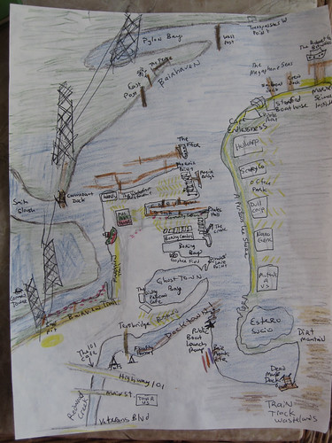
We have now mapped the tiny corner of our creek and given names to nameless places, extending human dominion to yet another junkyard and mudflat.

Chart of Pete's Harbor and Environs

As I kayaked around with my friend Adina she babbled to me charmingly of how we were in the same place but in a different place. Everything about the land and the water became different because we were on the water looking at the land. I agree! Distances open up hugely and pinch themselves up into almost nothing depending on the wind and current and tide. The parking lot of an office, a boring place, turns out to be the best fishing spot on the creek, full of families hanging off their truck tailgates.

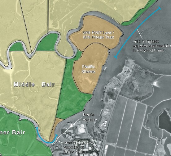
Many of my names for the creek are jokes but they reflect the way we are using the creek as kayakers and what we think is important. The places where trash collects, the strength of the current, the mudflats, the sticks and pilings and pylons that are landmarks, the place where the grebes hang out, the wind shadow of Middle Bair Island.

We remap our minds by traversing the edge of the known map. I was thinking about frontiers, wastelands, and edges. At Open Source Bridge I said some stuff about wastelands. When you hear a place described as empty, reach for your gun. Just kidding. No, when you hear a place described as empty, you can be sure someone is exploiting it. The desert, the wasteland, and the frontier, are obfuscations.

So in my naming of these places I open up different possibilities of exploitation, but since no space is unnamed and unobserved — they are named and observed and mapped by governments and corporations — I would prefer that they be named and observed in a decentralized way by anyone at all. (Which is one reason I adore Open Street Map and Open Sea Map.)

Voyages

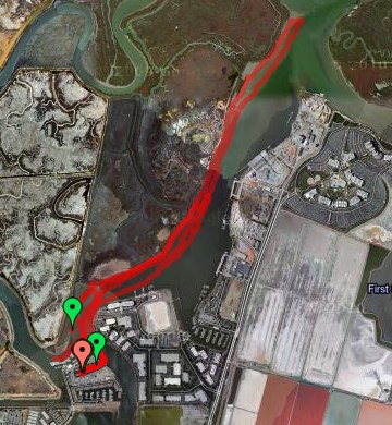
As I look back on the history of Bair Island and Redwood Creek I keep finding ghost places – like “South Shores” which was an attempt by a developer to rename the slough as a suburban extension of “Redwood Shores”. Or like Deepwater Slough, which still has a faint track on the satellite photo – the C shaped trace that loops across Middle Bair, across from the Port – the dredged mud and pickleweed it encloses still privately owned and still named “Pacific Shores” probably for some totally screwed up future condo development scheme.

Bair Island EIR map

The Bair Island history, its battles, and its 2006 EIR are all deep background good for anyone interested in the proposed 12,000 household development of the wetlands-turned-salt-ponds owned by Cargill. On the maps they’re the pink rectangular areas that barely even look like bay anymore.

A neighbor of mine across the harbor is gearing up for that battle on another blog, Virtual Saltworks. The ponds are still part of the bay and still supposed to be open space and wetlands. We could use a little bit of digging into maps and history – what was First Slough like before it was diked? What would it take to restore it at least to the state that Bair Island and Corkscrew Slough are in now?

Soon the abandoned docks and the piers for electric company access to overhead cables will be decorated underneath by pirate mailboxes where Milo and I will leave secret messages for the world.

I have some great ideas for Community Kayaks. They’d be like the civic projects for free bicycles anyone can use without fuss. It would be very easy and cheap to start and maintain a simple flotilla of boats free for anyone to use. More local people would use Redwood Creek, would see the edge of our town, the cultivated-wild places that exist right next to the industrial port where oceangoing cargo vessels offload their gypsum, sand, and gravel and load up clanking waterfalls of scrap metal. People barely care about the Creek because they don’t know it’s there. If they paddled around on it they might get fond of it.

I got a little obsessed with the Alviso boat ramp opening. If you live in Redwood City – do you know where the public boat launch ramps are? There are two that I know of!

What is the Bay for? Who gets to go on it? You shouldn’t have to be rich – or go on a giant ferryboat – or treat it like a sort of horrible wet golf course –

Where are my beautiful floating islands made of trash and full of ecological minded Burning Man hippies cultivating flats of pickleweed and nesting habitats for Caspian Terns? I also imagine a beautiful anarchosocialist cooperative marina with art projects and rogue marine science. It would be easy for us here in the harbor to be monitoring water quality, observing the plants and birds and fish, and so on. Decentralized maps and some kind of visionary open data project could make for some great open source science – I’m sure someone’s doing this already.