Danny just handed me a giant book called The Stack: On Software and Sovereignty, saying, “Just open that anywhere and start reading.” 20 seconds later I squawked OH MY GOD!!! WHAT IS THIS! WHAAAAAT!!!!!??!!!
He always brings me good things!
It’s very interesting! I kind of want to re-buy it on kindle (it’s too big for me to hold up in bed) and dig in. This is going to be a wild ride.
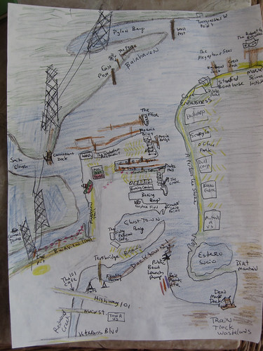
We have now mapped the tiny corner of our creek and given names to nameless places, extending human dominion to yet another junkyard and mudflat.
As I kayaked around with my friend Adina she babbled to me charmingly of how we were in the same place but in a different place. Everything about the land and the water became different because we were on the water looking at the land. I agree! Distances open up hugely and pinch themselves up into almost nothing depending on the wind and current and tide. The parking lot of an office, a boring place, turns out to be the best fishing spot on the creek, full of families hanging off their truck tailgates.
Many of my names for the creek are jokes but they reflect the way we are using the creek as kayakers and what we think is important. The places where trash collects, the strength of the current, the mudflats, the sticks and pilings and pylons that are landmarks, the place where the grebes hang out, the wind shadow of Middle Bair Island.
We remap our minds by traversing the edge of the known map. I was thinking about frontiers, wastelands, and edges. At Open Source Bridge I said some stuff about wastelands. When you hear a place described as empty, reach for your gun. Just kidding. No, when you hear a place described as empty, you can be sure someone is exploiting it. The desert, the wasteland, and the frontier, are obfuscations.
So in my naming of these places I open up different possibilities of exploitation, but since no space is unnamed and unobserved — they are named and observed and mapped by governments and corporations — I would prefer that they be named and observed in a decentralized way by anyone at all. (Which is one reason I adore Open Street Map and Open Sea Map.)
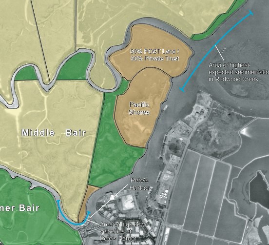
As I look back on the history of Bair Island and Redwood Creek I keep finding ghost places – like “South Shores” which was an attempt by a developer to rename the slough as a suburban extension of “Redwood Shores”. Or like Deepwater Slough, which still has a faint track on the satellite photo – the C shaped trace that loops across Middle Bair, across from the Port – the dredged mud and pickleweed it encloses still privately owned and still named “Pacific Shores” probably for some totally screwed up future condo development scheme.
The Bair Island history, its battles, and its 2006 EIR are all deep background good for anyone interested in the proposed 12,000 household development of the wetlands-turned-salt-ponds owned by Cargill. On the maps they’re the pink rectangular areas that barely even look like bay anymore.
A neighbor of mine across the harbor is gearing up for that battle on another blog, Virtual Saltworks. The ponds are still part of the bay and still supposed to be open space and wetlands. We could use a little bit of digging into maps and history – what was First Slough like before it was diked? What would it take to restore it at least to the state that Bair Island and Corkscrew Slough are in now?
Soon the abandoned docks and the piers for electric company access to overhead cables will be decorated underneath by pirate mailboxes where Milo and I will leave secret messages for the world.
I have some great ideas for Community Kayaks. They’d be like the civic projects for free bicycles anyone can use without fuss. It would be very easy and cheap to start and maintain a simple flotilla of boats free for anyone to use. More local people would use Redwood Creek, would see the edge of our town, the cultivated-wild places that exist right next to the industrial port where oceangoing cargo vessels offload their gypsum, sand, and gravel and load up clanking waterfalls of scrap metal. People barely care about the Creek because they don’t know it’s there. If they paddled around on it they might get fond of it.
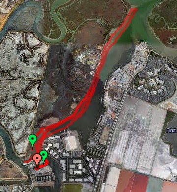
I got a little obsessed with the Alviso boat ramp opening. If you live in Redwood City – do you know where the public boat launch ramps are? There are two that I know of!
What is the Bay for? Who gets to go on it? You shouldn’t have to be rich – or go on a giant ferryboat – or treat it like a sort of horrible wet golf course –
Where are my beautiful floating islands made of trash and full of ecological minded Burning Man hippies cultivating flats of pickleweed and nesting habitats for Caspian Terns? I also imagine a beautiful anarchosocialist cooperative marina with art projects and rogue marine science. It would be easy for us here in the harbor to be monitoring water quality, observing the plants and birds and fish, and so on. Decentralized maps and some kind of visionary open data project could make for some great open source science – I’m sure someone’s doing this already.
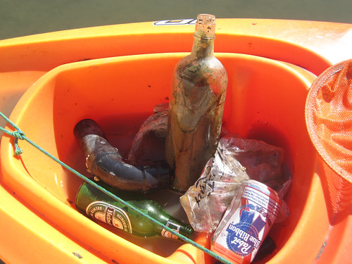
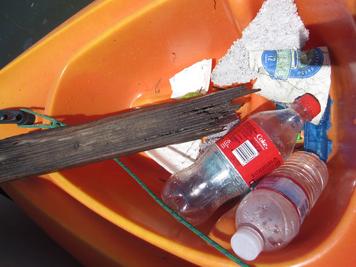
Here’s the kayak full of trash I picked up early this morning at low tide in Redwood Creek. It was a short, leisurely voyage in a glassy calm that made it easy to spot floating plastic bags and bottles.
The big glass bottle looks old to me, so I’m going to wash it out and keep it.
During unusually high tides there’s usually a lot of fast food containers, plastic bottlecaps, and styrofoam packing peanuts as well as a lemon or two.
Most of the time I forget to take a photo, but here’s another day’s worth of trash:
The most fertile grounds for trash are right up Redwood Creek past Highway 101. It’s only good to go there during a high tide at slack water.
On Valentine’s Day this year the Peninsula Yacht Club at Docktown led a big effort to pull trash from the creekside. In one day, they hauled out almost 2 tons of junk!
I think in the summer, Beth from Fake Plastic Fish might come do a trash collection voyage with me. Her blog is pretty cool – take a look. She lived for a year without consuming more than 5 pounds of plastic and she’s basically an activist against unnecessary plastic. After collecting trash from the creek, and during moments like watching seagulls fight over a coke bottle screw top and then one of them eating it, I can sure see where she’s coming from. The plastic bags in the marsh look like jellyfish floating.
In the Maldives there is an island made entirely of trash, Thilafushi Island. It’s built out of garbage and looks like an interesting place despite surely leaching out pollutants and hosting some industrial processing plants.
The island has grown to such proportions that it now has a café, a restaurant, two mosques, a barbershop, a clinic, a police station and rather unexpectedly, a makeshift zoo.
If we had a floating trash island in the San Francisco Bay, its growth would need to be limited, but it could be a very interesting place for eco-tourism or trash management tourism. I picture this floating trash island as a step further than Forbes Island or Spiral Island II, but smaller than Thilafushi. It could be a colony where people come stay and camp for a month and do volunteer Bay cleanup work with Trash Island as their base. There should also be a coffee cart and a nature center. It would be way more exciting to visit than Yet Another Bike Trail with Dogwalkers And Joggers In A Landfill. The price of admission would be that you take away a bag of trash. Okay, this is a half-baked idea… While I like the vision of seasteading as places for independent states, I tend to come up with slightly less ambitious ideas for cooperatively owned marinas or coastal cities with floating platforms that share some common purpose or radical politics — ecological cleanup and monitoring, public coastal access, and maybe some really cool art. In fact, I think that seasteading colonies will need to foster marinas with progressive politics in order to be viable. Seasteading needs a sort of marine-stuff-ecosystem in order to be viable. That might mean developing a close relationship with a working port city, or buying up and running its own port.
Speaking of public access! You should go to the Alviso Public Boat Ramp re-opening! Free kayak rides for kids and I’m sure a great party in a place with a long, interesting history.